
Send this article to a friend:
October
07
2017

|
Send this article to a friend: October |
|
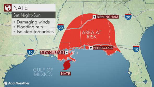
Nate to threaten US Gulf Coast as a hurricane this weekend
Flooding from Nate has already claimed lives in Central America. Anticipation of Nate's arrival has already prompted evacuations in low-lying coastal Louisiana parishes and Alabama counties. Gasoline and natural gas prices may rise. As a precaution, operations on offshore rigs in the projected path of Nate will wind down, according to Reuters. Evacuation of offshore rigs began on Thursday. Energy companies with refineries in the path of Nate were monitoring the situation for possible shutdown. Where is Nate likely to come ashore?
Conditions will rapidly deteriorate along the central Gulf coast from Saturday afternoon into Saturday night. People should not be on the road during this time. Nate is likely to make landfall somewhere from the western part of the Florida Panhandle to southeastern Louisiana. The exact point of landfall will be determined once the storm begins to move north of Mexico's Yucatan Peninsula. "In all likelihood, this storm will impact areas not severely impacted by Harvey or Irma. The extent of the damage will depend, of course, on the precise path and whether the storm intensifies beyond a Category 1 storm," AccuWeather Founder, President and Chairman Dr. Joel N. Myers said. From a climatological standpoint, most hurricanes have not made landfall in Texas or western Louisiana, but have moved inland farther to the east during October.
Similarly, only if Nate travels much farther east than currently forecast would flooding rain and high winds reach Irma-ravaged areas of Florida. How much may Nate strengthen? How serious the impacts are and exactly which areas are hardest hit by winds, waves and flooding will depend on the strength and track of the system. Nate is moving forward at more than 20 mph. This forward speed will limit the storm's ability to strengthen a great deal. RELATED: Nate is highly unlikely to make landfall as a Category 4 or greater storm. At this time, Nate is likely to make landfall in the U.S. as a Category 1 hurricane. However, a hurricane that reaches Category 1 strength has the potential to reach Category 2 or 3 (major hurricane) status in a matter of hours. Central Gulf coast threats from Nate include flooding and tornadoes Vulnerable, low-lying coastal areas, such as New Orleans; Mobile, Alabama; Biloxi, Mississippi; and Pensacola, Florida, should treat Nate as a serious threat for flooding from heavy rain and storm surge. New Orleans is below sea level and is protected by levees. "New Orleans levees that have been upgraded since Katrina and pumps that have been repaired in recent weeks may be tested this weekend," according to AccuWeather Expert Meteorologist and Chief Operating Officer Evan Myers.
Once this water is pushed into the lake, northerly winds on the back side of the hurricane can push the high water levels toward the northern shoreline of New Orleans. Officials have emergency generators on standby for pumping operations in New Orleans, according to NOLA.com. Out of 120 main line pumps, 108 are operational at this time. People are encouraged to heed all evacuation orders when they are given. In terms of rainfall and severe thunderstorms, the anticipated moisture versus dry air pattern will likely cause Nate to be lopsided.
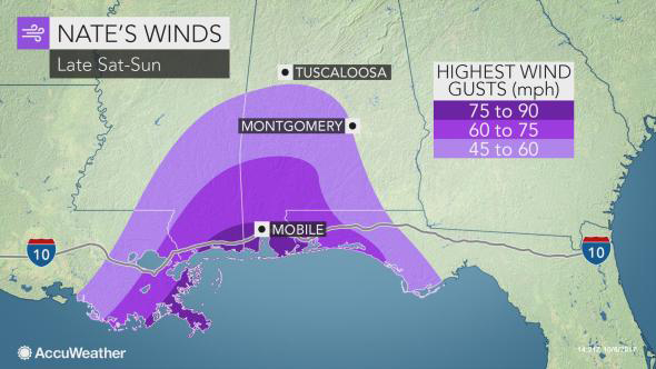
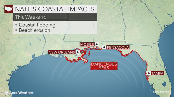
"Once Nate moves well inland, the heaviest rain will shift toward the north and northeast of the storm center later Sunday and Monday." Wind gusts will be strong enough to cause minor property damage, push down trees and lead to power outages. Isolated tornadoes can also occur well east of the center of Nate on Sunday and Monday. Rip current risk to extend along entire Gulf of Mexico coastline Wind and wave action will produce rough seas and dangerous surf throughout the Gulf of Mexico this weekend. The greatest coastal impacts will focus from part of the central Gulf coast to the upper west coast of the Florida Peninsula. Small craft throughout the Gulf of Mexico should remain in port this weekend. Bathers should avoid venturing beyond knee-deep water as the number and strength of rip currents will increase substantially even as far west as Texas. The potential for coastal flooding will extend well east of the center of the storm. AccuWeather is projecting a total of 17 tropical storms, which includes 11 hurricanes, through December 2017 in the Atlantic basin. The Atlantic basin includes the Gulf of Mexico and the Caribbean Sea. Hurricane season officially ends at the end of November. Including Nate, there have been 14 tropical storms, eight hurricanes and five major hurricanes thus far. "To stay safe, we urge people to keep checking AccuWeather.com and the AccuWeather apps for the latest developments," Dr. Myers said.
|
Send this article to a friend:
 |
 |
 |
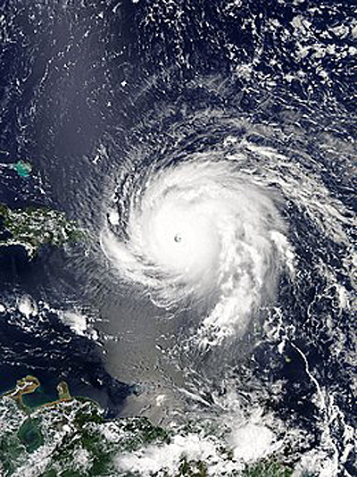 Nate will threaten part of the central Gulf of Mexico coast of the United States as a hurricane with flooding, strong winds and isolated tornadoes this weekend.
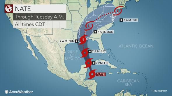

![[Most Recent Quotes from www.kitco.com]](http://www.kitconet.com/charts/metals/gold/t24_au_en_usoz_2.gif)
![[Most Recent USD from www.kitco.com]](http://www.weblinks247.com/indexes/idx24_usd_en_2.gif)
![[Most Recent Quotes from www.kitco.com]](http://www.kitconet.com/charts/metals/silver/t24_ag_en_usoz_2.gif)